Addition of the locality name of the address.
Example:
-
locality = Aach
-
postalCode = 78267 → localityAddition = Hegau
-
postalCode = 54298 → localityAddition = b Trier
The Reverse Geocoding API checks addresses based on coordinates and a defined tolerance.
The following table describes the input fields.
| Field | Range | Type | Description |
|---|---|---|---|
lat |
-90 to 90 |
BigDecimal |
Latitude of the WGS-84 coordinate. |
lon |
-180 to 180 |
BigDecimal |
Longitude of the WGS-84 coordinate. |
tolerance |
0 to 30 |
int |
Defines how far in meters can houses be from the best matching house to be included in the result |
The following table describes the output fields.
| Field | Type | Description |
|---|---|---|
distance |
int |
Distance from the address house to search point |
country |
string |
Country code of the address |
region |
string |
Region of the address. |
postalCode |
string |
Postal code of the address. |
locality |
string |
Locality name of the address. |
localityAbbreviation |
string |
Locality abbreviation of the address (can be the same name as the locality). |
localityAddition |
string |
Addition of the locality name of the address.
|
subLocality |
string |
Sub locality name of the address. |
subLocalityAbbreviation |
string |
Sub locality abbreviation of the address (can be the same name as the sub locality). |
street |
string |
Street name of the address. |
streetAbbreviation |
string |
Street abbreviation of the address (can be the same name as the street). |
houseNumber |
string |
House number of the address. |
coordinates |
object |
includes the wgs84 coordinates with latitude, longitude and precision. Precision is the accuracy level of the coordinates. The most accurate coordinate is at the house number level. 1. locality |
The search for coordinates will always return the candidate that is the closest to the entered coordinates.This candidate might not be the wanted address.With the tolerance the area, in witch the address will be searched, will be wider.After finding the nearest candidate the distance to the entered coordinates will be determined, to that distance the tolerance value will be added.
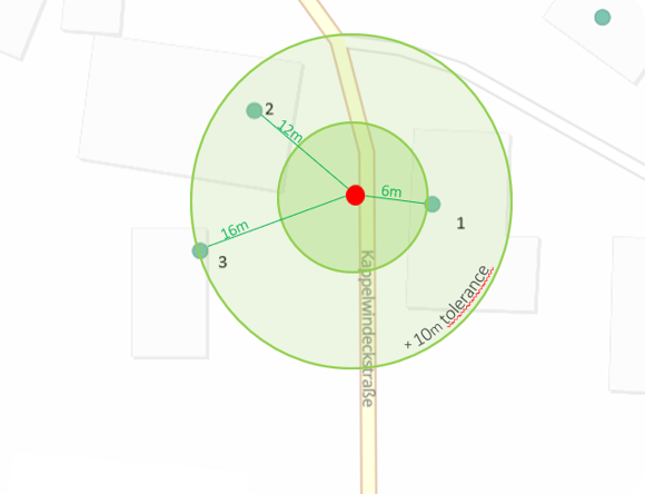
i.e.: There are 3 possible candidates in the search radius from the entered coordinates. First candidate: 6m Second candidate: 12m Third candidate: 16m If the tolerance is between 0 and 2m the result will only be candidate 1, because it is the nearest. A tolerance between 3m and 9m the result will also include candidate 2, because the search radius will be the 15m distance from candidate 1 plus the tolerance value. Tolerance between 10m and 12m, the result will be candiate 1, 2 and 3.